GIS
GIS SERVICES
AGM Site Documentation
Sub-meter XYZ Centerline
Pipe “Bending” Strain and Pipe Movement
Operator Database Management
In-house GIS Experts
CALL 800-752-1628 to learn more.
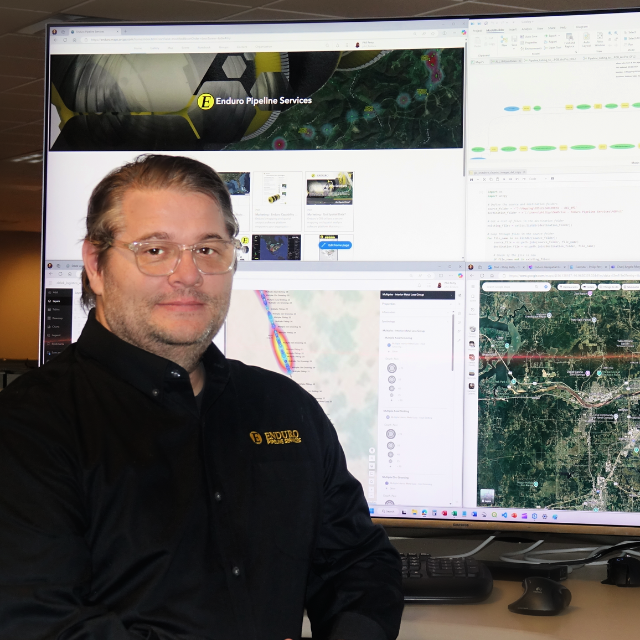
Our IMU navigation equipment is integrated within our ILI tools and works seamlessly with PigProg software, which includes specialized GIS capabilities. PigProg connects directly to ArcGIS, allowing clients to efficiently integrate deliverables into their existing GIS databases.
AGM Site documentation and field tracking services are available through Enduro. Tracking crews can collect XYZ data, capture site photographs, and produce required site documentation while in the field. This workflow significantly reduces turnaround time for final deliverables compared to traditional post-processing methods. When preparing for IMU services and sub-centimeter mapping, additional control points may also be collected in the field, helping reduce overall project time and cost.
As industry demand for pipe strain and movement analysis increases, Enduro has worked with specialists to develop systems that accurately report strain along the pipeline. By leveraging the GIS, geohazard data is integrated, and spatial analysis is applied to identify probable causes of strain events. Historical IMU datasets can also be analyzed to assess horizontal and vertical pipe movement over time.
Enduro also utilizes the ArcGIS Online Mapping Platform to support data delivery and collaboration. ArcGIS Online is a secure, scalable cloud-based platform for creating, analyzing, and sharing interactive web maps and applications. This allows clients to access up-to-date geospatial information, supporting informed decision-making and operational efficiency.
Benefits of Enduro's GIS Services
These benefits collectively enhance efficiency, accuracy, and compliance, ultimately supporting your operational success.
Accurate Data
Our collaboration with strain experts and use of advanced IMU navigation ensures precise reporting of pipe strain and movement.
Expert Support
Our in-house GIS experts provide specialized knowledge and support, enhancing the quality and reliability of our services.
Comprehensive Analysis
Utilizing ArcGIS and spatial analysis, we can identify probable causes of strain events and analyze pipeline movement, providing a thorough understanding of pipeline integrity.
Interactive Web Maps and Apps
You can create and analyze interactive web maps and apps, making it easier to visualize and understand geospatial data.
Integrated Solutions
Our PigProg software and ArcGIS integration make it easy to incorporate our deliverables into your existing GIS database.
Enhanced Collaboration
ArcGIS Online allows for easy sharing and collaboration, enabling multiple team members to access and work with the same data simultaneously.
Accessibility
Being a cloud-based platform, ArcGIS Online can be accessed from anywhere, providing flexibility and convenience for your team.
Improved Decision-Making
With up-to-date information and powerful analytical tools, you can make more informed decisions that enhance operational efficiency.
Are you ready to transform your organization with Enduro's GIS platform? Contact our certified Geographic Information Systems (GIS) professional, Phil Petty, at philipp@enduropls.com to unlock your potential and take the next step towards success!
Enduro's GIS Services was highlighted in the June 2025 PSA newsletter. You can read more about our GIS services here: PPSA Newsletter